Dating Google Earth Satellite Image with 5 Minutes Accuracy
Google Earth's images consist of a number of satellite images taken at various times. It is an ultimate challenge to find out, when exactly a certain picture has been taken. When I first tried Google Earth a couple of days after its launch, I noticed, the city of Bern, Swiss Capital, was not included in high resolution map yet.
After a couple of months though, I found out, that Bern had been added to the high resolution images.
Soon after, I began to wonder, at what time the picture had been taken.
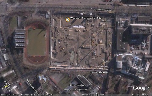
Here is how I found out: I needed to find a place on the map, that was not only constantly changing, but its change must also have been recorded and accessible to me. This was quite a challenge, however, I have found something, that perfectly suits the requirements. It was a construction site in the north of the city. The former "Wankdorf Stadion" (sic.) now referred to as "Stade de Suisse" is a football stadium, that has been built during the time, the satellite image has been taken.
I remembered, that there was also a webcam on site, that was recording the progress of the construction site. Luckily I have found the archive of these images and started comparing the pictures (that were taken every 5 minutes during 3 years) with the image visible on Google Earth. Since the vehicles are constantly moving on the site, you can determine at a approximately 5 to 10 minutes accuracy, when the satellite image must have been taken.
There is a number of elements, that indicate the time and allowed me to narrow down the time:
- Looking at the casted shadows of the cranes and tall objects led me to the assumption, the picture must have been taken at noon.
- The weather needs to be clear and cloudless in order to take satellite images
- The progress of the construction site is a good indicator
- The constellation and colors of the parked cars are also changing
Conclusion
The result of this small investigation was: The satellite image of Bern on Google Earth must have been taken between 11:25 hours and 11:30 on January the 30th 2002. Compare the Google Earth satellite image with this image.

Full size view of analysis
Animation of the 30th January 2002. Notice the red car at the far right leaving between 11:25 and 11:30. It is visible on the satellite image.

How about other days?
Too cloudy, progress with construction site not in sync or parked cars don't match:


Download KMZ of Wankdorf Stadion (Google Earth)
Thanks: Hansjürg Wenger of Berner Fachhochschule for providing me access to the archive images.
digg story
Update:
Thanks to James Turnbull for pointing out that there is a proof that I got the date right!
posted by christoph at 19:38
![]()


3 Comments:
Impressive. I marked the place over Google Maps, using our bookmarking tool Tagzania. Until now, the most precise datation that I knew was that of a bullring in Spain, where a copter was caught hours or minutes before an accident involving a notorious politician happened.
June 27, 2006 8:20 am
Cool, this is also a very nice find! ... Hopefully more people will find more clues how to date satellite images even more precisely!
June 27, 2006 10:50 pm
Though dating satellite images sounds like a somewhat nerdy spare time activity this is still very impressive :)
And nice... good job :D
July 18, 2006 12:25 pm
Post a Comment
<< Home