Sunday, September 10, 2006

Renaissance

This blog has been discontinued on blogger.com and will be continued on http://www.emcons.net/blog/ (Don't forget to adapt your RSS Feeds!)

Monday, August 14, 2006

Pin down your Digital Photos on a map with a GPS

Imagine, there would be meta information about every digital image, where actually you have taken it. Check it out here or here it gives photography a whole new dimension.

Now, if you have a GPS device and a Mac, you can use Jeffrey Early's GPSPhotoLinker to pin down any locations of your images, regardless which cam you are using, given that the GPS and your camera's time are perfectly synced and you carry both on you.

If you don't have a Mac, you may use Sony's new GPS Tracker. It comes in the form of a nice little key fob, so you can hang it on your backpack or belt.


All you have to make sure is, it doesn't get nicked.

Thanks: SeulKi

Sunday, August 13, 2006

Shaftesbury Avenue in London, 1949


Have a look at this great 18Megapixel picture from London in the late 1940ies!

Can you see the pickpocker in the brown suit of stealing the wallet of the gentleman just over the hood of the car to the left? The clue about the year 1949 came from the "Treasure Hunt" that seems to be playing in the "Apollo Theatre". This play was only on for a couple of months during 1949.

Via digg.com

Saturday, August 12, 2006

england-dot-co-dot-uk

I have a feeling, that Britain is currently going through something like an identity crisis.

The Union Jack is formally still the symbol of the United Kingdom of Great Britain and Northern Ireland. Formally and politically, England, Scotland, Wales and Northern Ireland form an unity. But not so in the minds of their peoples. We all know the story of Northern Ireland. The Scots have their own money and their own parliament, the Welsh their own language while the English have their own football team. Britain does't have a football team, but the national anthem Rooney & co are singing along and waving their St. Georges Cross to says "God save the Queen", which refers to Elizabeth the IInd who is the monarch not only of England, but of the entire Commonwealth Realms. On the other hand, Linford Christie, even though Jamaican-English, waved a Union Flag when he won the gold medal in the Olympic games 1992 in Barcelona. The Union Jack often gets associated with colonialism and British rule for example in some parts of Africa and still today, the British troops keep carrying the flag.

Since the sixties, the seek for identity manifests itself in the emblem actually becoming a fasion item.

Tuesday, July 25, 2006

Skype Video for Mac Os X Beta has arrived!

Finally! The long expected Skype Video Beta has arrived!

Saturday, July 15, 2006

Greetings from China

My sister currently works and studies in Shanghai, China. During her stay there, she takes videos and pictures.

Catch a couple of impressions on her current china video:

Sunday, June 25, 2006

Dating Google Earth Satellite Image with 5 Minutes Accuracy


GoogleEarth Image
Originally uploaded by christoph b..
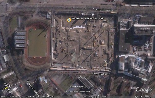
Google Earth's images consist of a number of satellite images taken at various times. It is an ultimate challenge to find out, when exactly a certain picture has been taken. When I first tried Google Earth a couple of days after its launch, I noticed, the city of Bern, Swiss Capital, was not included in high resolution map yet.

After a couple of months though, I found out, that Bern had been added to the high resolution images.

Soon after, I began to wonder, at what time the picture had been taken.

Here is how I found out: I needed to find a place on the map, that was not only constantly changing, but its change must also have been recorded and accessible to me. This was quite a challenge, however, I have found something, that perfectly suits the requirements. It was a construction site in the north of the city. The former "Wankdorf Stadion" (sic.) now referred to as "Stade de Suisse" is a football stadium, that has been built during the time, the satellite image has been taken.

I remembered, that there was also a webcam on site, that was recording the progress of the construction site. Luckily I have found the archive of these images and started comparing the pictures (that were taken every 5 minutes during 3 years) with the image visible on Google Earth. Since the vehicles are constantly moving on the site, you can determine at a approximately 5 to 10 minutes accuracy, when the satellite image must have been taken.

There is a number of elements, that indicate the time and allowed me to narrow down the time:
  • Looking at the casted shadows of the cranes and tall objects led me to the assumption, the picture must have been taken at noon.
  • The weather needs to be clear and cloudless in order to take satellite images
  • The progress of the construction site is a good indicator
  • The constellation and colors of the parked cars are also changing
So I started comparing the satellite image with the images found on http://www.wankdorf-stadion.ch/fotos/ which consists of more than 6 GB of webcam pictures taken and archived every 5 minutes 24/7.

Conclusion
The result of this small investigation was: The satellite image of Bern on Google Earth must have been taken between 11:25 hours and 11:30 on January the 30th 2002. Compare the Google Earth satellite image with this image.


Full size view of analysis


Animation of the 30th January 2002. Notice the red car at the far right leaving between 11:25 and 11:30. It is visible on the satellite image.


How about other days?
Too cloudy, progress with construction site not in sync or parked cars don't match:

Download KMZ of Wankdorf Stadion (Google Earth)

Thanks: Hansjürg Wenger of Berner Fachhochschule for providing me access to the archive images.

digg story

Update:
Thanks to James Turnbull for pointing out that there is a proof that I got the date right!